
Thank you for supporting this site ❤️
Make a donation
Make a donation
Acre topographic map
Click on the map to display elevation.
Thank you for supporting this site ❤️
Make a donation
Make a donation
About this map
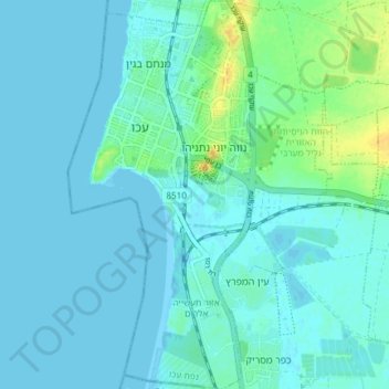
Name: Acre topographic map, elevation, terrain.
Location: Acre, Acre Subdistrict, North District, Israel (32.88636 35.06186 32.94853 35.11219)
Average elevation: 4 m
Minimum elevation: -1 m
Maximum elevation: 26 m
Thank you for supporting this site ❤️
Make a donation
Make a donation
Other topographic maps
Click on a map to view its topography, its elevation and its terrain.
Golan Heights
Israel > North District > Golan Regional Council
The plateau that Israel controls is part of a larger area of volcanic basalt fields stretching north and east that were created in the series of volcanic eruptions that began recently in geological terms, almost 4 million years ago. The rock forming the mountainous area in the northern Golan Heights,…
Average elevation: 533 m