
Thank you for supporting this site ❤️
Make a donation
Make a donation
Onda topographic map
Click on the map to display elevation.
Thank you for supporting this site ❤️
Make a donation
Make a donation
About this map
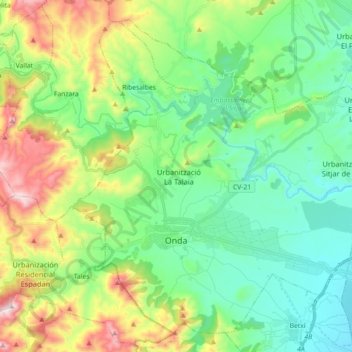
Name: Onda topographic map, elevation, terrain.
Average elevation: 259 m
Minimum elevation: 64 m
Maximum elevation: 713 m
Thank you for supporting this site ❤️
Make a donation
Make a donation
Other topographic maps
Click on a map to view its topography, its elevation and its terrain.
Castillo de Peñiscola
Spain > Valencian Community > Castelló / Castellón > Peníscola / Peñíscola
The castle is situated on a crag overlooking the Mediterranean Sea, at an altitude of 64 metres (210 ft) above mean sea level.
Average elevation: 5 m