
Thank you for supporting this site ❤️
Make a donation
Make a donation
Coutures topographic map
Click on the map to display elevation.
Thank you for supporting this site ❤️
Make a donation
Make a donation
About this map
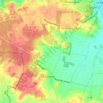
Name: Coutures topographic map, elevation, terrain.
Average elevation: 59 m
Minimum elevation: 21 m
Maximum elevation: 94 m
Thank you for supporting this site ❤️
Make a donation
Make a donation
Other topographic maps
Click on a map to view its topography, its elevation and its terrain.
Les Touches
France > Pays de la Loire > Maine-et-Loire > Brissac-Loire-Aubance
Average elevation: 66 m
Château de Brissac
France > Pays de la Loire > Maine-et-Loire > Brissac-Loire-Aubance
Average elevation: 49 m
Thank you for supporting this site ❤️
Make a donation
Make a donation
La Gaignardière
France > Pays de la Loire > Maine-et-Loire > Brissac-Loire-Aubance
Average elevation: 61 m
Le Moulin Roux
France > Pays de la Loire > Maine-et-Loire > Brissac-Loire-Aubance
Average elevation: 50 m