
Schwaz topographic map
Interactive map
Click on the map to display elevation.
About this map
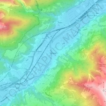
Name: Schwaz topographic map, elevation, terrain.
Location: Schwaz, Stadt Schwaz, Bezirk Schwaz, Tyrol, 6130, Austria (47.30495 11.66843 47.38495 11.74843)
Average elevation: 951 m
Minimum elevation: 523 m
Maximum elevation: 2,259 m
Other topographic maps
Click on a map to view its topography, its elevation and its terrain.
Marktgemeinde Mayrhofen
Austria > Tyrol > Bezirk Schwaz
Marktgemeinde Mayrhofen, Bezirk Schwaz, Tyrol, Austria
Average elevation: 1,983 m
Gemeinde Tux
Austria > Tyrol > Bezirk Schwaz
Gemeinde Tux, Bezirk Schwaz, Tyrol, Austria
Average elevation: 2,110 m
Gemeinde Zellberg
Austria > Tyrol > Bezirk Schwaz
Gemeinde Zellberg, Bezirk Schwaz, Tyrol, 6277, Austria
Average elevation: 1,352 m