
Soletta topographic map
Interactive map
Click on the map to display elevation.
About this map
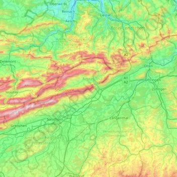
Name: Soletta topographic map, elevation, terrain.
Location: Soletta, Svizzera (47.07434 7.34041 47.50270 8.03137)
Average elevation: 593 m
Minimum elevation: 275 m
Maximum elevation: 1,427 m
Other topographic maps
Click on a map to view its topography, its elevation and its terrain.
Soletta
Svizzera > Soletta > Amtei Solothurn-Lebern
Soletta, Bezirk Solothurn, Amtei Solothurn-Lebern, Soletta, Svizzera
Average elevation: 449 m
Balm bei Günsberg
Svizzera > Soletta > Balm bei Günsberg
Balm bei Günsberg, Bezirk Lebern, Amtei Solothurn-Lebern, Soletta, 4525, Svizzera
Average elevation: 939 m
Sankt Niklaus
Svizzera > Soletta > Sankt Niklaus
Sankt Niklaus, Bezirk Lebern, Amtei Solothurn-Lebern, Soletta, 4532, Svizzera
Average elevation: 494 m