
Thank you for supporting this site ❤️
Make a donation
Make a donation
Parunthumpara topographic map
Click on the map to display elevation.
Thank you for supporting this site ❤️
Make a donation
Make a donation
About this map
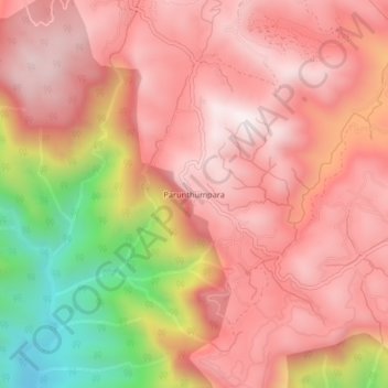
Name: Parunthumpara topographic map, elevation, terrain.
Location: Parunthumpara, Peerumade, Idukki District, Kerala, 685537, India (9.53031 77.01103 9.57031 77.05103)
Average elevation: 887 m
Minimum elevation: 294 m
Maximum elevation: 1,178 m
Thank you for supporting this site ❤️
Make a donation
Make a donation
Other topographic maps
Click on a map to view its topography, its elevation and its terrain.
Periyar National Park Tiger Reserve
Periyar National Park lies in the middle of a mountainous area of the Cardamom Hills. In the north : The boundary commences from the point nearest to the Medaganam in the interstate boundary up to Vellimalai. and the east Thence the boundary follows the inter-state boundary from Vellimalai to Kallimalai Peak…
Average elevation: 929 m
Thank you for supporting this site ❤️
Make a donation
Make a donation