
powiat suski topographic map
Interactive map
Click on the map to display elevation.
About this map
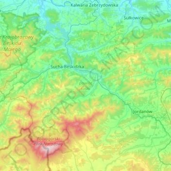
Name: powiat suski topographic map, elevation, terrain.
Location: powiat suski, Woiwodschap Klein-Polen, Polen (49.57145 19.36998 49.83155 19.91212)
Average elevation: 593 m
Minimum elevation: 255 m
Maximum elevation: 1,711 m
Other topographic maps
Click on a map to view its topography, its elevation and its terrain.
Beskidy
Polen > Woiwodschap Klein-Polen > powiat suski > Sidzina
Beskidy, Sidzina, gmina Bystra-Sidzina, powiat suski, Woiwodschap Klein-Polen, 34-236, Polen
Average elevation: 707 m