
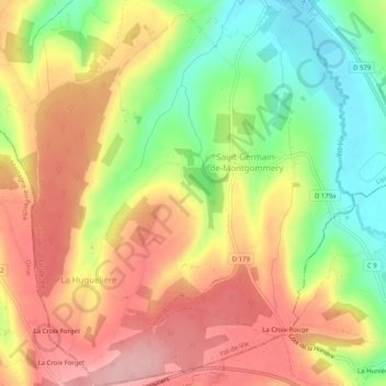
Saint-Germain-de-Montgommery topographic map
Interactive map
Click on the map to display elevation.
About this map
Name: Saint-Germain-de-Montgommery topographic map, elevation, terrain.
Average elevation: 165 m
Minimum elevation: 82 m
Maximum elevation: 236 m
Other topographic maps
Click on a map to view its topography, its elevation and its terrain.
Le Tailly
France > Normandie > Val-de-Vie
Le Tailly, Sainte-Foy-de-Montgommery, Val-de-Vie, Lisieux, Calvados, Normandie, France métropolitaine, 14140, France
Average elevation: 149 m