
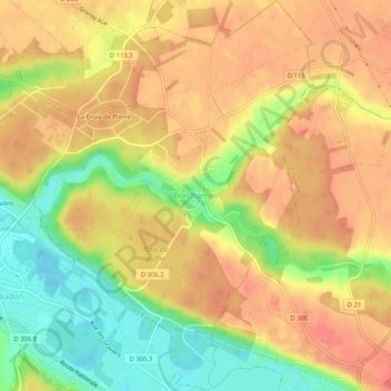
Bréchamps topographic map
Interactive map
Click on the map to display elevation.
About this map
Name: Bréchamps topographic map, elevation, terrain.
Average elevation: 121 m
Minimum elevation: 86 m
Maximum elevation: 142 m
Other topographic maps
Click on a map to view its topography, its elevation and its terrain.
Amilly
France > Centre-Val de Loire > Eure-et-Loir
Amilly, Chartres, Eure-et-Loir, Centre-Val de Loire, France métropolitaine, 28300, France
Average elevation: 159 m
Sainville
France > Centre-Val de Loire > Eure-et-Loir
Sainville, Chartres, Eure-et-Loir, Centre-Val de Loire, France métropolitaine, 28700, France
Average elevation: 152 m
Auneau-Bleury-Saint-Symphorien
France > Centre-Val de Loire > Eure-et-Loir
Auneau-Bleury-Saint-Symphorien, Chartres, Eure-et-Loir, Centre-Val de Loire, France métropolitaine, 28700, France
Average elevation: 150 m