
Kettershausen topographic map
Interactive map
Click on the map to display elevation.
About this map
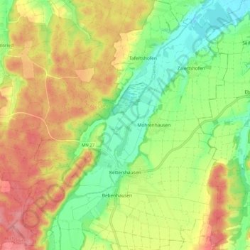
Name: Kettershausen topographic map, elevation, terrain.
Average elevation: 555 m
Minimum elevation: 504 m
Maximum elevation: 613 m
Other topographic maps
Click on a map to view its topography, its elevation and its terrain.
Schlegelsberg
Germany > Bavaria > Landkreis Unterallgäu
Schlegelsberg, Erkheim, Landkreis Unterallgäu, Bavaria, 87746, Germany
Average elevation: 617 m
Markt Wald
Germany > Bavaria > Landkreis Unterallgäu
Markt Wald, Landkreis Unterallgäu, Bavaria, 86865, Germany
Average elevation: 603 m