
Pierreville topographic map
Interactive map
Click on the map to display elevation.
About this map
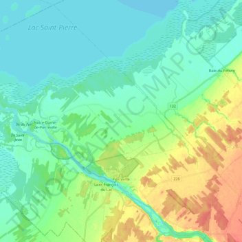
Name: Pierreville topographic map, elevation, terrain.
Average elevation: 16 m
Minimum elevation: 1 m
Maximum elevation: 52 m
Other topographic maps
Click on a map to view its topography, its elevation and its terrain.
Saint-Léonard-d'Aston
Canada > Québec > Nicolet-Yamaska
Saint-Léonard-d'Aston, Nicolet-Yamaska, Centre-du-Québec, Québec, J0C 1M0, Canada
Average elevation: 77 m
Saint-François-du-Lac
Canada > Québec > Nicolet-Yamaska > Saint-François-du-Lac > Saint-François-du-Lac
Saint-François-du-Lac, Nicolet-Yamaska, Centre-du-Québec, Québec, J0G 1X0, Canada
Average elevation: 22 m