
Make a donation
Constanța topographic map
Click on the map to display elevation.
Make a donation
Constanța
Spring arrives early but it is quite cool. Often in April and May the Black Sea coast is one of the coolest places in Romania found at an altitude lower than 500 m (1,640 ft).
Make a donation
About this map
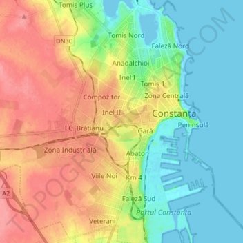
Name: Constanța topographic map, elevation, terrain.
Location: Constanța, Constanta Metropolitan Area, Constanța, Romania (44.12435 28.55037 44.22137 28.67624)
Average elevation: 31 m
Minimum elevation: -4 m
Maximum elevation: 72 m
Make a donation
Other topographic maps
Click on a map to view its topography, its elevation and its terrain.
Dobrogea
Except for the Danube Delta, a marshy region located in its northeastern corner, Dobruja is hilly, with an average altitude of about 200–300 metres. The highest point is the Țuțuiatu (Greci) Peak in the Măcin Mountains, having a height of 467 m. The Dobruja Plateau covers most of the Romanian part of…
Average elevation: 53 m
Make a donation
Make a donation