
Hainfeld topographic map
Interactive map
Click on the map to display elevation.
About this map
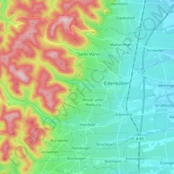
Name: Hainfeld topographic map, elevation, terrain.
Average elevation: 289 m
Minimum elevation: 125 m
Maximum elevation: 671 m
Other topographic maps
Click on a map to view its topography, its elevation and its terrain.
Herxheim
Deutschland > Rheinland-Pfalz > Landkreis Südliche Weinstraße > Herxheim
Herxheim, Landkreis Südliche Weinstraße, Rheinland-Pfalz, 76863, Deutschland
Average elevation: 130 m