
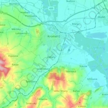
Kroměříž topographic map
Interactive map
Click on the map to display elevation.
About this map
Name: Kroměříž topographic map, elevation, terrain.
Average elevation: 220 m
Minimum elevation: 181 m
Maximum elevation: 368 m
Kroměříž is located about 20 kilometres (12 mi) northwest of Zlín. About two thirds of the municipal territory lies in the Litenčice Hills, eastern part lies in the Upper Morava Valley. A small southern part extends into the Chřiby mountain range. The highest point of the territory is the hill Obora with an elevation of 322 metres (1,056 ft). The town is situated on both banks of the Morava River.
Other topographic maps
Click on a map to view its topography, its elevation and its terrain.
Sazovice
Czechia > Central Moravia > Zlínský kraj
Sazovice, okres Zlín, Zlínský kraj, Central Moravia, Czechia
Average elevation: 235 m
Stupava
Czechia > Central Moravia > Zlínský kraj
Stupava, okres Uherské Hradiště, Zlínský kraj, Central Moravia, Czechia
Average elevation: 428 m
Roštín
Czechia > Central Moravia > Zlínský kraj
Roštín, okres Kroměříž, Zlínský kraj, Central Moravia, 768 03, Czechia
Average elevation: 353 m
Rožnov pod Radhoštěm
Czechia > Central Moravia > Zlínský kraj
Rožnov pod Radhoštěm, okres Vsetín, Zlínský kraj, Central Moravia, 756 61, Czechia
Average elevation: 521 m