
Thank you for supporting this site ❤️
Make a donation
Make a donation
Lake Lafayette topographic map
Click on the map to display elevation.
Thank you for supporting this site ❤️
Make a donation
Make a donation
About this map
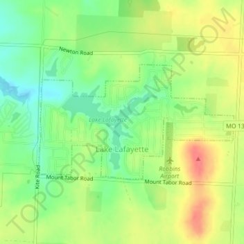
Name: Lake Lafayette topographic map, elevation, terrain.
Location: Lake Lafayette, Lafayette County, Missouri, United States (38.94250 -93.98331 38.95520 -93.95539)
Average elevation: 276 m
Minimum elevation: 248 m
Maximum elevation: 306 m
Thank you for supporting this site ❤️
Make a donation
Make a donation