
Thank you for supporting this site ❤️
Make a donation
Make a donation
Les Ribes topographic map
Click on the map to display elevation.
Thank you for supporting this site ❤️
Make a donation
Make a donation
About this map
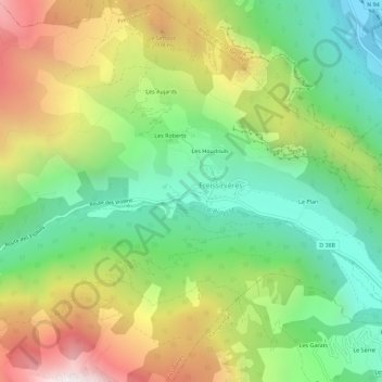
Name: Les Ribes topographic map, elevation, terrain.
Average elevation: 1,573 m
Minimum elevation: 952 m
Maximum elevation: 2,503 m
Thank you for supporting this site ❤️
Make a donation
Make a donation
Other topographic maps
Click on a map to view its topography, its elevation and its terrain.
Gîte-Refuge de l’École
France > Provence-Alpes-Côte d'Azur > Hautes-Alpes > Freissinières > Dormillouse
Average elevation: 1,977 m