
Schochwitz topographic map
Interactive map
Click on the map to display elevation.
About this map
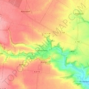
Name: Schochwitz topographic map, elevation, terrain.
Location: Schochwitz, Salzatal, Saalekreis, Sachsen-Anhalt, Deutschland (51.51363 11.71325 51.55451 11.79771)
Average elevation: 157 m
Minimum elevation: 86 m
Maximum elevation: 198 m
Zu Schochwitz gehören der Hauptort Schochwitz sowie die Ortsteile Boltzenhöhe, Gorsleben, Krimpe, Räther und Wils.
Other topographic maps
Click on a map to view its topography, its elevation and its terrain.
Höhnstedt
Deutschland > Sachsen-Anhalt > Saalekreis > Salzatal > Höhnstedt
Höhnstedt, Salzatal, Saalekreis, Sachsen-Anhalt, Deutschland
Average elevation: 147 m
Schiepzig
Deutschland > Sachsen-Anhalt > Saalekreis > Salzatal
Schiepzig, Salzatal, Saalekreis, Sachsen-Anhalt, Deutschland
Average elevation: 93 m
Pfützthal
Deutschland > Sachsen-Anhalt > Saalekreis > Salzatal > Gödewitz
Pfützthal, Salzmünde, Gödewitz, Salzatal, Saalekreis, Sachsen-Anhalt, 06198, Deutschland
Average elevation: 107 m
Lieskau
Deutschland > Sachsen-Anhalt > Saalekreis > Salzatal
Lieskau, Salzatal, Saalekreis, Sachsen-Anhalt, Deutschland
Average elevation: 107 m