
Thank you for supporting this site ❤️
Make a donation
Make a donation
Crestwood topographic map
Click on the map to display elevation.
Thank you for supporting this site ❤️
Make a donation
Make a donation
About this map
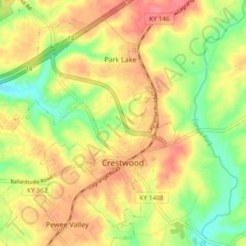
Name: Crestwood topographic map, elevation, terrain.
Location: Crestwood, Oldham County, Kentucky, United States (38.31016 -85.52390 38.35352 -85.45845)
Average elevation: 223 m
Minimum elevation: 183 m
Maximum elevation: 257 m
Thank you for supporting this site ❤️
Make a donation
Make a donation