
Cardosas topographic map
Interactive map
Click on the map to display elevation.
About this map
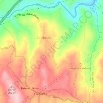
Name: Cardosas topographic map, elevation, terrain.
Location: Cardosas, Arruda dos Vinhos, Lisboa, Portugal (38.96017 -9.05680 38.98663 -9.02189)
Average elevation: 156 m
Minimum elevation: 32 m
Maximum elevation: 259 m
Other topographic maps
Click on a map to view its topography, its elevation and its terrain.
S. Tiago dos Velhos
Portugal > Lisboa > Arruda dos Vinhos
S. Tiago dos Velhos, Arruda dos Vinhos, Lisboa, Portugal
Average elevation: 243 m