
Schalkenmehren topographic map
Interactive map
Click on the map to display elevation.
About this map
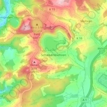
Name: Schalkenmehren topographic map, elevation, terrain.
Average elevation: 453 m
Minimum elevation: 364 m
Maximum elevation: 557 m
Other topographic maps
Click on a map to view its topography, its elevation and its terrain.
Weinfelder Maar
Germany > Rhineland-Palatinate > Landkreis Vulkaneifel > Schalkenmehren
Weinfelder Maar, Schalkenmehren, Daun, Landkreis Vulkaneifel, Rhineland-Palatinate, 54552, Germany
Average elevation: 467 m