Pauri topographic map
Interactive map
Click on the map to display elevation.
About this map
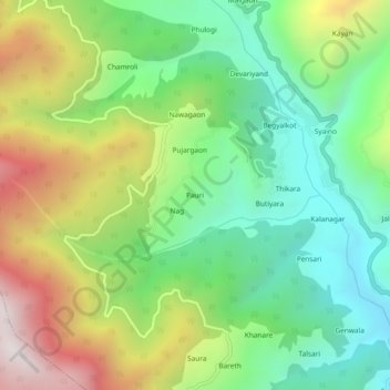
Name: Pauri topographic map, elevation, terrain.
Location: Pauri, Dunda, Uttarkashi district, Uttarakhand, 249152, India (30.69177 78.25229 30.73177 78.29229)
Average elevation: 1,680 m
Minimum elevation: 1,206 m
Maximum elevation: 2,462 m
Other topographic maps
Click on a map to view its topography, its elevation and its terrain.
Sartali
India > Uttarakhand > Dunda
Sartali, Dunda, Uttarkashi district, Uttarakhand, 249152, India
Average elevation: 1,775 m
Gwana
India > Uttarakhand > Dunda
Gwana, Dunda, Uttarkashi district, Uttarakhand, 249151, India
Average elevation: 1,429 m