
Thank you for supporting this site ❤️
Make a donation
Make a donation
Flagpond Copse topographic map
Click on the map to display elevation.
Thank you for supporting this site ❤️
Make a donation
Make a donation
About this map
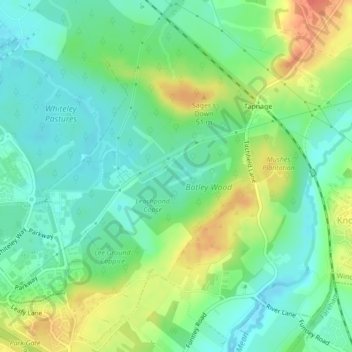
Name: Flagpond Copse topographic map, elevation, terrain.
Average elevation: 26 m
Minimum elevation: 7 m
Maximum elevation: 58 m
Thank you for supporting this site ❤️
Make a donation
Make a donation
Other topographic maps
Click on a map to view its topography, its elevation and its terrain.
Bishop's Waltham
United Kingdom > England > Hampshire > Winchester > Bishop's Waltham
Average elevation: 62 m
Thank you for supporting this site ❤️
Make a donation
Make a donation