
Refugio de Vida Silvestre Laquipampa topographic map
Interactive map
Click on the map to display elevation.
About this map
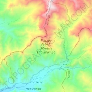
Name: Refugio de Vida Silvestre Laquipampa topographic map, elevation, terrain.
Average elevation: 1,051 m
Minimum elevation: 196 m
Maximum elevation: 2,623 m
Other topographic maps
Click on a map to view its topography, its elevation and its terrain.
Ayamachay
Perú > Lambayeque > Incahuasi
Ayamachay, Incahuasi, Ferreñafe, Lambayeque, Perú
Average elevation: 2,825 m
Uyurpampa
Perú > Lambayeque > Incahuasi
Uyurpampa, Incahuasi, Ferreñafe, Lambayeque, Perú
Average elevation: 2,907 m
Hacienda Janque
Perú > Lambayeque > Incahuasi > Hacienda Janque
Hacienda Janque, Incahuasi, Provincia de Ferreñafe, Lambayeque, Perú
Average elevation: 2,247 m