
Thank you for supporting this site ❤️
Make a donation
Make a donation
Mansalay topographic map
Click on the map to display elevation.
Thank you for supporting this site ❤️
Make a donation
Make a donation
About this map
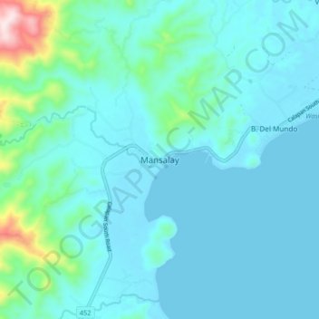
Name: Mansalay topographic map, elevation, terrain.
Location: Mansalay, Oriental Mindoro, Mimaropa, Philippines (12.48050 121.39898 12.56050 121.47898)
Average elevation: 58 m
Minimum elevation: 0 m
Maximum elevation: 461 m
Thank you for supporting this site ❤️
Make a donation
Make a donation
Other topographic maps
Click on a map to view its topography, its elevation and its terrain.
Calapan
Philippines > Oriental Mindoro
The overall land characteristic is a wide plain with rivers, interspersed with wetlands at the seacoast periphery. The highest elevation is 187 m (614 ft) above sea level at Bulusan Hill, a 6-kilometre (3.7 mi) long landform east of the city, which interrupts the mostly flat terrain north-east of the…
Average elevation: 12 m