
Thank you for supporting this site ❤️
Make a donation
Make a donation
La Placette topographic map
Click on the map to display elevation.
Thank you for supporting this site ❤️
Make a donation
Make a donation
About this map
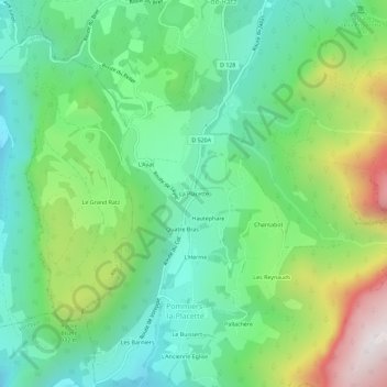
Name: La Placette topographic map, elevation, terrain.
Average elevation: 733 m
Minimum elevation: 381 m
Maximum elevation: 1,491 m
Thank you for supporting this site ❤️
Make a donation
Make a donation
Other topographic maps
Click on a map to view its topography, its elevation and its terrain.
Saint-Julien-de-Raz
France > Auvergne-Rhône-Alpes > Isère > La Sure en Chartreuse
Average elevation: 600 m
Pommiers-la-Placette
France > Auvergne-Rhône-Alpes > Isère > La Sure en Chartreuse
Average elevation: 1,052 m