
Thank you for supporting this site ❤️
Make a donation
Make a donation
Fairfield Township topographic map
Click on the map to display elevation.
Thank you for supporting this site ❤️
Make a donation
Make a donation
Fairfield Township
Fairfield Township's name is reflective of the gentle topography in the township. It is one of seven Fairfield Townships statewide.
Thank you for supporting this site ❤️
Make a donation
Make a donation
About this map
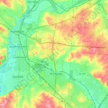
Name: Fairfield Township topographic map, elevation, terrain.
Average elevation: 207 m
Minimum elevation: 164 m
Maximum elevation: 276 m
Thank you for supporting this site ❤️
Make a donation
Make a donation
Other topographic maps
Click on a map to view its topography, its elevation and its terrain.