
Souris topographic map
Interactive map
Click on the map to display elevation.
About this map
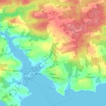
Name: Souris topographic map, elevation, terrain.
Location: Souris, Kings County, Prince Edward Island, Canada (46.33544 -62.29540 46.40542 -62.22013)
Average elevation: 33 m
Minimum elevation: -3 m
Maximum elevation: 79 m
Other topographic maps
Click on a map to view its topography, its elevation and its terrain.
Albion
Canada > Prince Edward Island > Kings County
Albion, Town of Three Rivers, Kings County, Prince Edward Island, Canada
Average elevation: 13 m
Sturgeon
Canada > Prince Edward Island > Kings County
Sturgeon, Town of Three Rivers, Kings County, Prince Edward Island, Canada
Average elevation: 12 m
St. Patrick Road
Canada > Prince Edward Island > Kings County
St. Patrick Road, Kings County, Prince Edward Island, Canada
Average elevation: 45 m
Georgetown
Canada > Prince Edward Island > Kings County
Georgetown, Town of Three Rivers, Kings County, Prince Edward Island, Canada
Average elevation: 9 m
Maitland Flat
Canada > Prince Edward Island > Kings County > DeGros Marsh
Maitland Flat, DeGros Marsh, Town of Three Rivers, Kings County, Prince Edward Island, Canada
Average elevation: 5 m
Cardigan
Canada > Prince Edward Island > Kings County > Cardigan
Cardigan, Town of Three Rivers, Kings County, Prince Edward Island, Canada
Average elevation: 27 m
Lower Montague
Canada > Prince Edward Island > Kings County > Lower Montague
Lower Montague, Town of Three Rivers, Kings County, Prince Edward Island, C0A 1R0, Canada
Average elevation: 15 m