
Isla Hoste topographic map
Interactive map
Click on the map to display elevation.
About this map
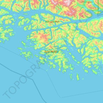
Name: Isla Hoste topographic map, elevation, terrain.
Average elevation: 170 m
Minimum elevation: -4 m
Maximum elevation: 2,285 m
Other topographic maps
Click on a map to view its topography, its elevation and its terrain.
Kap Hoorn
Chile > Region von Magellan und der chilenischen Antarktis > Provinz der chilenischen Antarktis > Kap Hoorn
Kap Hoorn, Provinz der chilenischen Antarktis, Region von Magellan und der chilenischen Antarktis, Chile
Average elevation: 92 m
Punta Arenas
Chile > Region von Magellan und der chilenischen Antarktis > Provincia de Magallanes > Punta Arenas
Punta Arenas, Provincia de Magallanes, Region von Magellan und der chilenischen Antarktis, Chile
Average elevation: 187 m
Natales
Chile > Region von Magellan und der chilenischen Antarktis > Provincia de Última Esperanza > Natales
Natales, Provincia de Última Esperanza, Region von Magellan und der chilenischen Antarktis, Chile
Average elevation: 353 m
Isla Doble Pico
Chile > Region von Magellan und der chilenischen Antarktis > Natales
Isla Doble Pico, Natales, Provincia de Última Esperanza, Region von Magellan und der chilenischen Antarktis, Chile
Average elevation: 15 m
Isla Aguirre
Chile > Region von Magellan und der chilenischen Antarktis > Kap Hoorn
Isla Aguirre, Kap Hoorn, Provinz der chilenischen Antarktis, Region von Magellan und der chilenischen Antarktis, Chile
Average elevation: 67 m