Clarksville topographic map
Interactive map
Click on the map to display elevation.
About this map
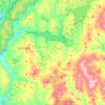
Name: Clarksville topographic map, elevation, terrain.
Location: Clarksville, Coös County, New Hampshire, United States (44.95950 -71.48851 45.05613 -71.17152)
Average elevation: 570 m
Minimum elevation: 312 m
Maximum elevation: 1,001 m
According to the United States Census Bureau, the town has a total area of 62.4 square miles (161.5 km2), of which 60.3 square miles (156.3 km2) are land and 2.0 square miles (5.2 km2) are water, comprising 3.24% of the town. The highest point in Clarksville is Crystal Mountain, at 3,230 feet (980 m) above sea level, near the town's southern border. Significant water bodies include portions of Lake Francis, Clarksville Pond, Carr Pond and Dead Water Stream. The western two-thirds of Clarksville lies within the Connecticut River watershed and the eastern third in the Androscoggin River watershed. Clarksville's town hall, elevation 1,980 feet (600 m), is the highest town hall in the state. (The town hall of Washington is located at a lower elevation—1,507 feet (459 m)—but has other village development there, and is therefore the highest town center in the state.)
Other topographic maps
Click on a map to view its topography, its elevation and its terrain.
Kidderville
United States > New Hampshire > Coos County > Colebrook
Kidderville, Colebrook, Coös County, New Hampshire, United States
Average elevation: 472 m
Dixville
United States > New Hampshire > Coos County
Dixville, Coös County, New Hampshire, United States
Average elevation: 635 m
Mount Washington
United States > New Hampshire > Coos County
Mount Washington, Coös County, New Hampshire, United States
Average elevation: 1,568 m
Northumberland
United States > New Hampshire > Coos County
Northumberland, Coös County, New Hampshire, United States
Average elevation: 383 m
Stark
United States > New Hampshire > Coos County
Stark, Coös County, New Hampshire, United States
Average elevation: 526 m
Shelburne
United States > New Hampshire > Coos County
Shelburne, Coös County, New Hampshire, United States
Average elevation: 467 m
Groveton
United States > New Hampshire > Coos County
Groveton, Northumberland, Coös County, New Hampshire, United States
Average elevation: 304 m
Columbia
United States > New Hampshire > Coos County
Columbia, Coös County, New Hampshire, United States
Average elevation: 553 m
Dummer
United States > New Hampshire > Coos County
Dummer, Coös County, New Hampshire, United States
Average elevation: 419 m
Twin Mountain
United States > New Hampshire > Coos County > Carroll
Twin Mountain, Carroll, Coös County, New Hampshire, 03595, United States
Average elevation: 490 m
Pinkham Notch
United States > New Hampshire > Coos County
Pinkham Notch, Pinkham's Grant, Coös County, New Hampshire, United States
Average elevation: 767 m
Milan
United States > New Hampshire > Coos County
Milan, Coös County, New Hampshire, 03588, United States
Average elevation: 448 m
Stratford
United States > New Hampshire > Coos County
Stratford, Coös County, New Hampshire, 03590, United States
Average elevation: 497 m
Castellated Ridge
United States > New Hampshire > Coos County
Castellated Ridge, Low and Burbank's Grant, Coös County, New Hampshire, United States
Average elevation: 1,080 m
Lost Nation
United States > New Hampshire > Coos County > Northumberland
Lost Nation, Northumberland, Coös County, New Hampshire, United States
Average elevation: 363 m
North Stratford
United States > New Hampshire > Coos County
North Stratford, Stratford, Coös County, New Hampshire, 03590, United States
Average elevation: 340 m
Colebrook
United States > New Hampshire > Coos County
Colebrook, Coös County, New Hampshire, 03576, United States
Average elevation: 476 m
Whitefield
United States > New Hampshire > Coos County
Whitefield, Coös County, New Hampshire, United States
Average elevation: 365 m
Gorham
United States > New Hampshire > Coos County
Gorham, Coös County, New Hampshire, 03581, United States
Average elevation: 477 m
Wildcat Mountain
United States > New Hampshire > Coos County
Wildcat Mountain, Coös County, New Hampshire, United States
Average elevation: 1,055 m
Upper Kidderville
United States > New Hampshire > Coos County > Colebrook
Upper Kidderville, Colebrook, Coos County, New Hampshire, United States
Average elevation: 478 m
Pittsburg
United States > New Hampshire > Coos County
Pittsburg, Coös County, New Hampshire, United States
Average elevation: 522 m
Castle Mountain
United States > New Hampshire > Coos County
Castle Mountain, Coos County, New Hampshire, United States
Average elevation: 937 m
Carroll
United States > New Hampshire > Coos County
Carroll, Coös County, New Hampshire, United States
Average elevation: 562 m
Lancaster
United States > New Hampshire > Coos County
Lancaster, Coös County, New Hampshire, 03584, United States
Average elevation: 371 m
Bretton Woods
United States > New Hampshire > Coos County > Carroll
Bretton Woods, Carroll, Coös County, New Hampshire, 03575, United States
Average elevation: 577 m
Mount Crescent
United States > New Hampshire > Coos County
Mount Crescent, Coos County, New Hampshire, 03593, United States
Average elevation: 748 m
Triple Falls
United States > New Hampshire > Coos County > Gorham
Triple Falls, Gorham, Coos County, New Hampshire, 03593, United States
Average elevation: 558 m
Randolph
United States > New Hampshire > Coos County
Randolph, Coös County, New Hampshire, 03593, United States
Average elevation: 594 m
LIttle Diamond Pond
United States > New Hampshire > Coos County > Stewartstown
LIttle Diamond Pond, Stewartstown, Coos County, New Hampshire, United States
Average elevation: 693 m
Jefferson Highland
United States > New Hampshire > Coos County > Jefferson > Jefferson Highland
Jefferson Highland, Jefferson, Coos County, New Hampshire, 03583, United States
Average elevation: 451 m
Jefferson
United States > New Hampshire > Coos County
Jefferson, Coös County, New Hampshire, 03583, United States
Average elevation: 493 m
Dixville Notch
United States > New Hampshire > Coos County
Dixville Notch, Coos County, New Hampshire, United States
Average elevation: 655 m
Dalton
United States > New Hampshire > Coos County
Dalton, Coös County, New Hampshire, United States
Average elevation: 375 m
Stewartstown
United States > New Hampshire > Coos County
Stewartstown, Coös County, New Hampshire, 03597, United States
Average elevation: 485 m
Errol
United States > New Hampshire > Coos County
Errol, Coös County, New Hampshire, United States
Average elevation: 453 m
Mount Eisenhower
United States > New Hampshire > Coos County
Mount Eisenhower, Coos County, New Hampshire, 03589, United States
Average elevation: 1,142 m