
Thank you for supporting this site ❤️
Make a donation
Make a donation
Hillegossen topographic map
Click on the map to display elevation.
Thank you for supporting this site ❤️
Make a donation
Make a donation
About this map
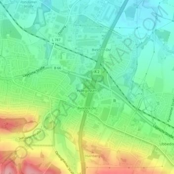
Name: Hillegossen topographic map, elevation, terrain.
Average elevation: 138 m
Minimum elevation: 96 m
Maximum elevation: 219 m
Thank you for supporting this site ❤️
Make a donation
Make a donation
Other topographic maps
Click on a map to view its topography, its elevation and its terrain.
Burg und Festung Sparrenberg
Deutschland > Nordrhein-Westfalen > Bielefeld
Um den Erhalt und die Sanierung der Anlage finanziell sicherzustellen, wurde die Aktion Ein Stein für die Burg initiiert, bei der gegen Geldspenden die Patenschaft für einen Stein in der Burgmauer übernommen werden konnte. Bei höheren Spendensummen war eine persönliche Gravur des Steins möglich.…
Average elevation: 145 m
Thank you for supporting this site ❤️
Make a donation
Make a donation