
Thank you for supporting this site ❤️
Make a donation
Make a donation
Wiebelsheim topographic map
Click on the map to display elevation.
Thank you for supporting this site ❤️
Make a donation
Make a donation
About this map
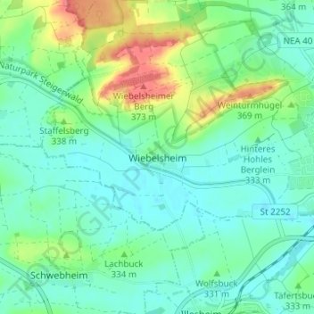
Name: Wiebelsheim topographic map, elevation, terrain.
Average elevation: 328 m
Minimum elevation: 309 m
Maximum elevation: 376 m
Thank you for supporting this site ❤️
Make a donation
Make a donation
Other topographic maps
Click on a map to view its topography, its elevation and its terrain.
91438
Deutschland > Bayern > Landkreis Neustadt an der Aisch-Bad Windsheim > Bad Windsheim > Erkenbrechtshofen
Average elevation: 333 m