
Huntsville topographic map
Interactive map
Click on the map to display elevation.
About this map
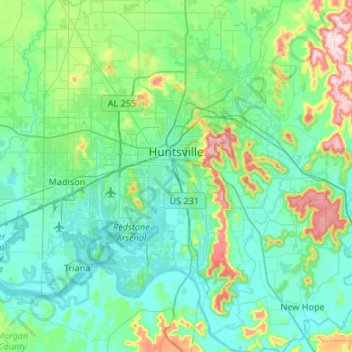
Name: Huntsville topographic map, elevation, terrain.
Location: Huntsville, Madison County, Alabama, États-Unis d'Amérique (34.53343 -86.93117 34.86516 -86.39933)
Average elevation: 230 m
Minimum elevation: 166 m
Maximum elevation: 540 m
Other topographic maps
Click on a map to view its topography, its elevation and its terrain.
Normal
États-Unis d'Amérique > Alabama > Madison County > Huntsville
Normal, Huntsville, Madison County, Alabama, 35810, États-Unis d'Amérique
Average elevation: 236 m