
Gemeinde Elbigenalp topographic map
Interactive map
Click on the map to display elevation.
About this map
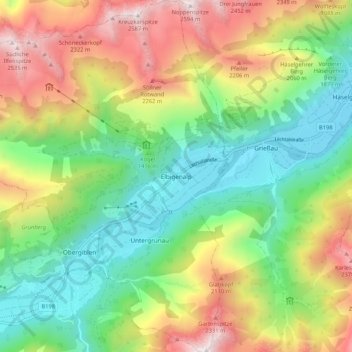
Name: Gemeinde Elbigenalp topographic map, elevation, terrain.
Location: Gemeinde Elbigenalp, Bezirk Reutte, Tyrol, 6652, Austria (47.25528 10.35362 47.32692 10.45289)
Average elevation: 1,667 m
Minimum elevation: 1,018 m
Maximum elevation: 2,589 m
Other topographic maps
Click on a map to view its topography, its elevation and its terrain.
Gemeinde Breitenwang
Austria > Tyrol > Bezirk Reutte
Gemeinde Breitenwang, Bezirk Reutte, Tyrol, Austria
Average elevation: 1,253 m