
Queijas topographic map
Interactive map
Click on the map to display elevation.
About this map
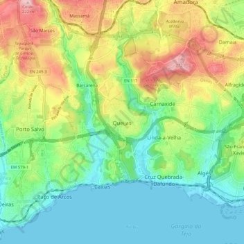
Name: Queijas topographic map, elevation, terrain.
Average elevation: 78 m
Minimum elevation: 0 m
Maximum elevation: 223 m
Other topographic maps
Click on a map to view its topography, its elevation and its terrain.
Parque Florestal de Monsanto
Portugal > Lisboa > Carnaxide e Queijas > Carnaxide
Parque Florestal de Monsanto, Estrada dos Cabos de Ávila, Bairro 18 de Maio, Carnaxide, Carnaxide e Queijas, Oeiras, Lisboa, 2610-008, Portugal
Average elevation: 95 m
Carnaxide
Portugal > Lisboa > Carnaxide e Queijas > Carnaxide
Carnaxide, Carnaxide e Queijas, Oeiras, Lisboa, Portugal
Average elevation: 104 m