
Thank you for supporting this site ❤️
Make a donation
Make a donation
Mirik topographic map
Click on the map to display elevation.
Thank you for supporting this site ❤️
Make a donation
Make a donation
About this map
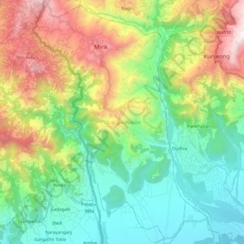
Name: Mirik topographic map, elevation, terrain.
Location: Mirik, Darjeeling, West Bengal, India (26.75197 88.13622 26.92034 88.25412)
Average elevation: 784 m
Minimum elevation: 166 m
Maximum elevation: 2,051 m
Thank you for supporting this site ❤️
Make a donation
Make a donation