
Basel-Landschaft topographic map
Interactive map
Click on the map to display elevation.
About this map
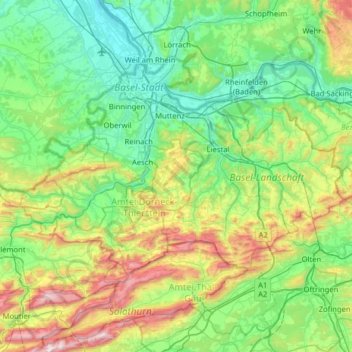
Name: Basel-Landschaft topographic map, elevation, terrain.
Location: Basel-Landschaft, Schweiz (47.33788 7.32528 47.56437 7.96183)
Average elevation: 524 m
Minimum elevation: 228 m
Maximum elevation: 1,411 m
Other topographic maps
Click on a map to view its topography, its elevation and its terrain.
Frenkendorf
Schweiz > Basel-Landschaft > Bezirk Liestal
Frenkendorf, Bezirk Liestal, Basel-Landschaft, 4402, Schweiz
Average elevation: 381 m
Rümlingen
Schweiz > Basel-Landschaft > Bezirk Sissach
Rümlingen, Bezirk Sissach, Basel-Landschaft, 4444, Schweiz
Average elevation: 552 m