
Plynlimon topographic map
Interactive map
Click on the map to display elevation.
About this map
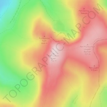
Name: Plynlimon topographic map, elevation, terrain.
Location: Plynlimon, Ceredigion, Wales, SY23 3AG, United Kingdom (52.46687 -3.78309 52.46697 -3.78299)
Average elevation: 583 m
Minimum elevation: 349 m
Maximum elevation: 749 m
Other topographic maps
Click on a map to view its topography, its elevation and its terrain.
Aberporth
United Kingdom > Wales > Ceredigion
Aberporth, Ceredigion, Wales, SA43 2DB, United Kingdom
Average elevation: 62 m
Aberystwyth
United Kingdom > Wales > Ceredigion
Aberystwyth, Ceredigion, Wales, SY23 1LH, United Kingdom
Average elevation: 39 m
Cardigan
United Kingdom > Wales > Ceredigion > Cardigan
Cardigan, Ceredigion, Wales, SA43 1JR, United Kingdom
Average elevation: 81 m
Ynyslas
United Kingdom > Wales > Ceredigion > Borth > Ynyslas
Ynyslas, Borth, Ceredigion, Wales, SY24 5JX, United Kingdom
Average elevation: 1 m