
Weißseespitze - Cima del Lago Bianco topographic map
Interactive map
Click on the map to display elevation.
About this map
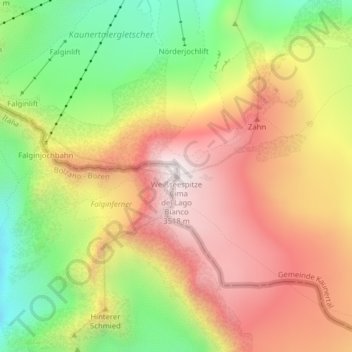
Name: Weißseespitze - Cima del Lago Bianco topographic map, elevation, terrain.
Average elevation: 3,108 m
Minimum elevation: 2,681 m
Maximum elevation: 3,489 m
Other topographic maps
Click on a map to view its topography, its elevation and its terrain.
Graun - Curon Venosta
Italië > Trento-Zuid-Tirol > Graun - Curon Venosta
Graun - Curon Venosta, Vinschgau - Val Venosta, BZ, Trento-Zuid-Tirol, 39027, Italië
Average elevation: 2,252 m