
Make a donation
Lake Erie topographic map
Click on the map to display elevation.
Make a donation
Lake Erie
Situated below Lake Huron, Erie's primary inlet is the Detroit River. The main natural outflow from the lake is via the Niagara River, which provides hydroelectric power to Canada and the U.S. as it spins huge turbines near Niagara Falls at Lewiston, New York, and Queenston, Ontario. Some outflow occurs via the Welland Canal, part of the Saint Lawrence Seaway, which diverts water for ship passages from Port Colborne, Ontario, on Lake Erie, to St. Catharines on Lake Ontario, an elevation difference of 326 ft (99 m). Lake Erie's environmental health has been an ongoing concern for decades, with issues such as overfishing, pollution, algae blooms, and eutrophication generating headlines.
Make a donation
About this map
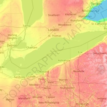
Name: Lake Erie topographic map, elevation, terrain.
Location: Lake Erie, Ohio, United States (41.38068 -83.47871 42.90584 -78.84648)
Average elevation: 267 m
Minimum elevation: 73 m
Maximum elevation: 769 m
Make a donation
Other topographic maps
Click on a map to view its topography, its elevation and its terrain.
Make a donation
Make a donation
Make a donation
Make a donation
Make a donation
Mansfield
United States > Ohio > Richland County > Mansfield > Mansfield
Mansfield is located at 40°45′17″N 82°31′22″W / 40.75472°N 82.52278°W / 40.75472; -82.52278 (40.754856, −82.522855), directly between Columbus and Cleveland, however, the city lies in the western foothills of the Allegheny Plateau, and its elevation is among the highest of Ohio cities.…
Average elevation: 371 m
Cleveland
United States > Ohio > Cuyahoga County > Cleveland
The land rises quickly from the lake shore elevation of 569 feet. Public Square, less than one mile (1.6 km) inland, sits at an elevation of 650 feet (198 m), and Hopkins Airport, 5 miles (8 km) inland from the lake, is at an elevation of 791 feet (241 m).
Average elevation: 221 m
Make a donation
Cedar Creek Woods
United States > Ohio > Wood County > Northwood > Cedar Creek Woods
Average elevation: 185 m
Make a donation
Pine Lake Estates
United States > Ohio > Fairfield County > Pine Lake Estates
Average elevation: 298 m
Make a donation