
Eden topographic map
Interactive map
Click on the map to display elevation.
About this map
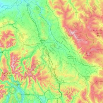
Name: Eden topographic map, elevation, terrain.
Location: Eden, Cumbria, North West England, Inglaterra, Reino Unido (54.35475 -3.09429 54.85642 -2.15899)
Average elevation: 318 m
Minimum elevation: 13 m
Maximum elevation: 934 m
Other topographic maps
Click on a map to view its topography, its elevation and its terrain.
Ullswater
Reino Unido > Inglaterra > Eden
Ullswater, A592, Matterdale, Eden, Cumbria, North West England, Inglaterra, CA10 2NF, Reino Unido
Average elevation: 299 m