
Huara topographic map
Interactive map
Click on the map to display elevation.
About this map
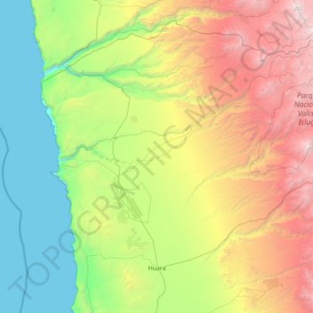
Name: Huara topographic map, elevation, terrain.
Location: Huara, Provincia del Tamarugal, Región de Tarapacá, Chile (-20.10204 -70.28622 -18.96648 -68.90793)
Average elevation: 1,633 m
Minimum elevation: 0 m
Maximum elevation: 5,536 m
Other topographic maps
Click on a map to view its topography, its elevation and its terrain.
Tarapacá
Chile > Región de Tarapacá > Huara > Tarapacá
Tarapacá, Huara, Provincia del Tamarugal, Región de Tarapacá, Chile
Average elevation: 1,506 m