
Attica topographic map
Interactive map
Click on the map to display elevation.
About this map
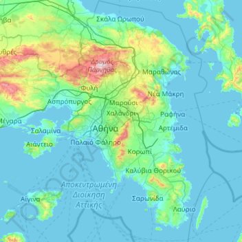
Name: Attica topographic map, elevation, terrain.
Location: Attica, Greece (37.64831 23.10669 38.34101 24.08594)
Average elevation: 133 m
Minimum elevation: -1 m
Maximum elevation: 1,384 m
Other topographic maps
Click on a map to view its topography, its elevation and its terrain.
Marousi
Greece > Attica > Regional Unit of North Athens
Marousi, Municipality of Marousi, Regional Unit of North Athens, Attica, 151 24, Greece
Average elevation: 257 m
Athens
Greece > Attica > Regional Unit of Central Athens
Athens, Municipality of Athens, Regional Unit of Central Athens, Attica, 104 31, Greece
Average elevation: 178 m
Hydra
Greece > Attica > Regional Unit of Islands > Vlychos
Hydra, Vlychos, Municipality of Hydra, Regional Unit of Islands, Attica, 180 40, Greece
Average elevation: 26 m
Municipal Unit of Ano Liosia
Greece > Attica > Regional Unit of West Attica
Municipal Unit of Ano Liosia, Municipality of Fyli, Regional Unit of West Attica, Attica, Greece
Average elevation: 356 m
Municipality of Chalandri
Greece > Attica > Regional Unit of North Athens > Municipality of Chalandri
Municipality of Chalandri, Regional Unit of North Athens, Attica, Greece
Average elevation: 208 m
Marathon
Greece > Attica > Regional Unit of East Attica
Marathon, Municipality of Marathonas, Regional Unit of East Attica, Attica, 190 07, Greece
Average elevation: 146 m