
La Vilette topographic map
Interactive map
Click on the map to display elevation.
About this map
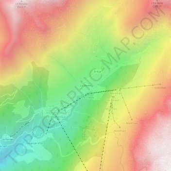
Name: La Vilette topographic map, elevation, terrain.
Average elevation: 1,753 m
Minimum elevation: 868 m
Maximum elevation: 2,626 m
Other topographic maps
Click on a map to view its topography, its elevation and its terrain.
Grand Vaujany
France > Auvergne-Rhône-Alpes > Isère > Vaujany
Grand Vaujany, Vaujany, Grenoble, Isère, Auvergne-Rhône-Alpes, France métropolitaine, 38114, France
Average elevation: 1,572 m
Pourchery
France > Auvergne-Rhône-Alpes > Isère > Vaujany
Pourchery, Vaujany, Grenoble, Isère, Auvergne-Rhône-Alpes, France métropolitaine, 38114, France
Average elevation: 1,228 m
La Condamine
France > Auvergne-Rhône-Alpes > Isère > Vaujany
La Condamine, Vaujany, Grenoble, Isère, Auvergne-Rhône-Alpes, France métropolitaine, 38114, France
Average elevation: 1,217 m
Petit Vaujany
France > Auvergne-Rhône-Alpes > Isère > Vaujany > Petit Vaujany
Petit Vaujany, Vaujany, Grenoble, Isère, Auvergne-Rhône-Alpes, France métropolitaine, 38114, France
Average elevation: 1,489 m