
Stadt Lienz topographic map
Interactive map
Click on the map to display elevation.
About this map
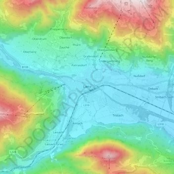
Name: Stadt Lienz topographic map, elevation, terrain.
Location: Stadt Lienz, Bezirk Lienz, Tyrol, 9900, Austria (46.81399 12.69537 46.84517 12.80862)
Average elevation: 1,072 m
Minimum elevation: 654 m
Maximum elevation: 2,026 m
Other topographic maps
Click on a map to view its topography, its elevation and its terrain.
Ströden
Austria > Tyrol > Bezirk Lienz > Gemeinde Prägraten am Großvenediger
Ströden, Gemeinde Prägraten am Großvenediger, Bezirk Lienz, Tyrol, Austria
Average elevation: 1,895 m
Gemeinde Abfaltersbach
Austria > Tyrol > Bezirk Lienz
Gemeinde Abfaltersbach, Bezirk Lienz, Tyrol, 9913, Austria
Average elevation: 1,585 m