
Раївська сільська громада topographic map
Interactive map
Click on the map to display elevation.
About this map
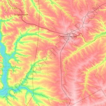
Name: Раївська сільська громада topographic map, elevation, terrain.
Average elevation: 130 m
Minimum elevation: 45 m
Maximum elevation: 196 m
Other topographic maps
Click on a map to view its topography, its elevation and its terrain.
Nikopol
Ukraine > Dnipropetrovsk Oblast
Nikopol, Nikopol Municipality, Dnipropetrovsk Oblast, Ukraine
Average elevation: 30 m
Auly
Ukraine > Dnipropetrovsk Oblast > Auly
Auly, Krynychky Raion, Dnipropetrovsk Oblast, 52310-52312, Ukraine
Average elevation: 116 m