
Annaghmore topographic map
Interactive map
Click on the map to display elevation.
About this map
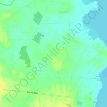
Name: Annaghmore topographic map, elevation, terrain.
Location: Annaghmore, Northern Ireland, United Kingdom (54.63837 -6.53627 54.65139 -6.51173)
Average elevation: 18 m
Minimum elevation: 9 m
Maximum elevation: 32 m
Other topographic maps
Click on a map to view its topography, its elevation and its terrain.
White Island
United Kingdom > Northern Ireland
White Island, Fermanagh and Omagh District, Northern Ireland, United Kingdom
Average elevation: 56 m
Saul
United Kingdom > Northern Ireland
Saul, Newry, Mourne and Down District Council, Northern Ireland, BT30 6SY, United Kingdom
Average elevation: 34 m
Strabane
United Kingdom > Northern Ireland > County Tyrone
Strabane, County Tyrone, Northern Ireland, BT82 8AH, United Kingdom
Average elevation: 71 m
Newry, Mourne and Down District Council
United Kingdom > Northern Ireland
Newry, Mourne and Down District Council, Northern Ireland, United Kingdom
Average elevation: 69 m
Carrickfergus
United Kingdom > Northern Ireland > County Antrim
Carrickfergus, County Antrim, Ulster, Northern Ireland, BT38 7AF, United Kingdom
Average elevation: 49 m
Coleraine
United Kingdom > Northern Ireland > County Londonderry
Coleraine, County Londonderry, Northern Ireland, BT52 1DP, United Kingdom
Average elevation: 40 m
Castlerock
United Kingdom > Northern Ireland > County Londonderry
Castlerock, County Londonderry, Ulster, Northern Ireland, BT51 4RA, United Kingdom
Average elevation: 23 m
Hilltown
United Kingdom > Northern Ireland > County Down
Hilltown, County Down, Ulster, Northern Ireland, BT34 5UH, United Kingdom
Average elevation: 136 m
Gorran
United Kingdom > Northern Ireland
Gorran, Ulster, Northern Ireland, United Kingdom
Average elevation: 83 m
Ahoghill
United Kingdom > Northern Ireland > County Antrim
Ahoghill, County Antrim, Ulster, Northern Ireland, BT42 1JZ, United Kingdom
Average elevation: 84 m
Portrush
United Kingdom > Northern Ireland > County Antrim
Portrush, County Antrim, Ulster, Northern Ireland, BT56 8BN, United Kingdom
Average elevation: 23 m
Ballymena
United Kingdom > Northern Ireland > County Antrim
Ballymena, County Antrim, Northern Ireland, BT43 6DT, United Kingdom
Average elevation: 74 m
Larne
United Kingdom > Northern Ireland > County Antrim
Larne, County Antrim, Northern Ireland, BT40 1JS, United Kingdom
Average elevation: 54 m
Belfast
United Kingdom > Northern Ireland > County Antrim
Belfast, County Antrim, Ulster, Northern Ireland, BT1 5GS, United Kingdom
Average elevation: 87 m
Rathfriland
United Kingdom > Northern Ireland > Rathfriland
Rathfriland, County Down, Northern Ireland, BT34 5NH, United Kingdom
Average elevation: 97 m
White Island
United Kingdom > Northern Ireland > County Fermanagh
White Island, County Fermanagh, Northern Ireland, United Kingdom
Average elevation: 48 m
Coalisland
United Kingdom > Northern Ireland > Coalisland
Coalisland, County Tyrone, Northern Ireland, BT71 4NB, United Kingdom
Average elevation: 59 m
Raffrey
United Kingdom > Northern Ireland
Raffrey, Northern Ireland, United Kingdom
Average elevation: 54 m
County Down
United Kingdom > Northern Ireland
County Down, Northern Ireland, United Kingdom
Average elevation: 65 m
Bangor
United Kingdom > Northern Ireland > County Down
Bangor, County Down, Northern Ireland, BT20 5AG, United Kingdom
Average elevation: 40 m
Holywood
United Kingdom > Northern Ireland > Holywood
Holywood, County Down, Northern Ireland, BT18 9AE, United Kingdom
Average elevation: 44 m
Newry
United Kingdom > Northern Ireland > Newry
Newry, County Down, Northern Ireland, United Kingdom
Average elevation: 73 m
Cookstown
United Kingdom > Northern Ireland > Cookstown
Cookstown, County Tyrone, Northern Ireland, BT80 8PF, United Kingdom
Average elevation: 67 m
Antrim
United Kingdom > Northern Ireland > County Antrim
Antrim, County Antrim, Northern Ireland, BT41 4AR, United Kingdom
Average elevation: 50 m
Rostrevor
United Kingdom > Northern Ireland > Rostrevor
Rostrevor, County Down, Northern Ireland, BT34 3BG, United Kingdom
Average elevation: 78 m
Ballynahinch
United Kingdom > Northern Ireland > Ballynahinch
Ballynahinch, County Down, Northern Ireland, BT24 8DN, United Kingdom
Average elevation: 99 m
Low Wood
United Kingdom > Northern Ireland > Belfast
Low Wood, Belfast, County Antrim, Northern Ireland, United Kingdom
Average elevation: 64 m
Ballygolan
United Kingdom > Northern Ireland > Belfast
Ballygolan, Belfast, County Antrim, Northern Ireland, United Kingdom
Average elevation: 98 m
Slieve Donard
United Kingdom > Northern Ireland
Slieve Donard, County Down, Northern Ireland, BT33 0HD, United Kingdom
Average elevation: 503 m
Lisdrumgullion
United Kingdom > Northern Ireland > Newry
Lisdrumgullion, Newry, County Down, Northern Ireland, BT35 6BH, United Kingdom
Average elevation: 41 m