
Petit lac Noir topographic map
Interactive map
Click on the map to display elevation.
About this map
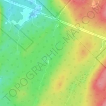
Name: Petit lac Noir topographic map, elevation, terrain.
Average elevation: 340 m
Minimum elevation: 296 m
Maximum elevation: 392 m
Other topographic maps
Click on a map to view its topography, its elevation and its terrain.
Petit lac Neigette
Canada > Québec > La Mitis > Lac-des-Eaux-Mortes
Petit lac Neigette, Lac-des-Eaux-Mortes, La Mitis, Bas-Saint-Laurent, Québec, Canada
Average elevation: 293 m
Le Trou à Eustache
Canada > Québec > La Mitis > Lac-des-Eaux-Mortes
Le Trou à Eustache, Lac-des-Eaux-Mortes, La Mitis, Bas-Saint-Laurent, Québec, Canada
Average elevation: 330 m
Lac-des-Eaux-Mortes
Canada > Québec > La Mitis > Lac-des-Eaux-Mortes
Lac-des-Eaux-Mortes, La Mitis, Bas-Saint-Laurent, Québec, Canada
Average elevation: 380 m