
Thank you for supporting this site ❤️
Make a donation
Make a donation
Adjumani topographic map
Click on the map to display elevation.
Thank you for supporting this site ❤️
Make a donation
Make a donation
About this map
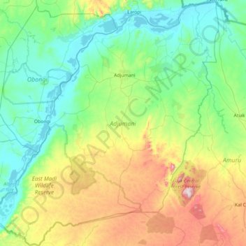
Name: Adjumani topographic map, elevation, terrain.
Location: Adjumani, Northern Region, Uganda (2.88094 31.40031 3.59291 32.06292)
Average elevation: 808 m
Minimum elevation: 613 m
Maximum elevation: 1,387 m
Thank you for supporting this site ❤️
Make a donation
Make a donation
Other topographic maps
Click on a map to view its topography, its elevation and its terrain.