
Étang de Liffré topographic map
Interactive map
Click on the map to display elevation.
About this map
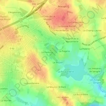
Name: Étang de Liffré topographic map, elevation, terrain.
Average elevation: 87 m
Minimum elevation: 54 m
Maximum elevation: 115 m
Other topographic maps
Click on a map to view its topography, its elevation and its terrain.
La Coulée Verte
La Coulée Verte, Maison Forestière des Brosses, Liffré, Rennes, Ille-et-Vilaine, Bretagne, France métropolitaine, 35340, France
Average elevation: 93 m
Carrefour de la Petite Lune
Carrefour de la Petite Lune, Liffré, Rennes, Ille-et-Vilaine, Bretagne, France métropolitaine, 35340, France
Average elevation: 75 m