
Dreieckhorn topographic map
Interactive map
Click on the map to display elevation.
About this map
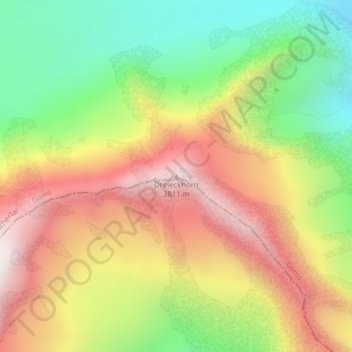
Name: Dreieckhorn topographic map, elevation, terrain.
Location: Dreieckhorn, Fieschertal, Goms, Vallese, Svizzera (46.47812 8.01987 46.47822 8.01997)
Average elevation: 3,209 m
Minimum elevation: 2,663 m
Maximum elevation: 3,792 m
Other topographic maps
Click on a map to view its topography, its elevation and its terrain.
Hinter Fiescherhorn
Svizzera > Vallese > Fieschertal
Hinter Fiescherhorn, Fieschertal, Goms, Vallese, Svizzera
Average elevation: 3,511 m
Trugberg
Svizzera > Vallese > Fieschertal
Trugberg, Fieschertal, Goms, Vallese, Svizzera
Average elevation: 3,457 m
Fiescher Gabelhorn
Svizzera > Vallese > Fieschertal
Fiescher Gabelhorn, Fieschertal, Goms, Vallese, Svizzera
Average elevation: 3,299 m
Jungfraujoch
Svizzera > Vallese > Fieschertal
Jungfraujoch, Fieschertal, Goms, Vallese, 3801, Svizzera
Average elevation: 3,307 m
Finsteraarhorn
Svizzera > Vallese > Fieschertal
Finsteraarhorn, Fieschertal, Goms, Vallese, Svizzera
Average elevation: 3,420 m
Ebnefluh/Äbeni Flue
Svizzera > Vallese > Fieschertal
Ebnefluh/Äbeni Flue, Fieschertal, Goms, Vallese, Svizzera
Average elevation: 3,430 m